STATEN LANT

Travel Diary of Jacob Le Maire and Schouten Wilhem, January 1616:

"Very early in the morning we saw land to the right at a mile distance, going southeast. We sounded and had 40 fathoms, with southwind along the coast of this mountainous land covered with snow. After noon, we saw land to the east which was a mountainous and broken land.These lands would be far about 8 miles one from the other.

Around noon the currents were large. We were in 54 degrees, 46 minutes. After noon, we found northwind that carried us to the strait. The wind dropped in the afternoon and this evening we were taken by the current and saw many penguins and whales.We were now close to the land recently discovered on the East. High and broken, apparently running southeastwards. We gave it the name "Statelant", in our language "Land of the States..."

With this vision of a rugged land elongated dutch sailors became the first men to discover the location of the island. Its initial name was due to the mistaken belief that it was a peninsula of Terra Australis. The Staten word referred to the 7 provinces of the Netherlands, which at that time were fighting for their independence. Years later, in 1643, Hendrick Brouwer circumnavigated Statenlant, noting that it was in fact an island and not a part of the continent. Thus, The Staten Island, a small bastion of rock of 65 miles long and a max. width of 16 kms., battered by waves and Antartic winds appeared in the future maritime cartography, separated from the island of Tierra del Fuego by the Strait of Le Maire.

George anson, a British commander, wrote in 1790: "It`s a horror territory, with peaks of prodigious height and terrifying precipices, it is difficult to imagine anything more savage and gloomy."

The dramatic description of Anson is due in large part to the rugged geography of the island. Its 530 square miles(including isla Año Nuevo(New Year Island) and Dampier and Menzies Islands, are comprised of twp mountain ranges that cross the island from end to end, with deep valleys, bogs, lakes, fjords, bays and cliffs that fall to the sea. Walking on the island is difficult.Everything around seems to be made of solid rock and the wild vegetation and the tall silhouettes of the mountains seem to close on the observer as walls.

These conditions and the isolation of its location, made this island a perfect fortness at sea among the mist. And indeed, over time, that was exactly what became


7 abr 2010

OUR PASSION


It is known that this activity was originated in the northern hemisphere by the Inuits, Eskimos and other peoples in those areas, however we must also recognize that our indigenous people also navigated these dangerous waters in the south.

The Yamanas crossed the dangerous Strait of Le Maire in their fragile canoes.
They called it “Chuanisin” (Place of Abundance”). Testimonies of these visits were recorded in 1982 by archaeologists and anthropologists in Crossley Bay.

Today the same connection will take place. An ancient navigation through virgin territory like thousands of years ago, the man, his craft and nature in its purest essence.

Our kayaks have evolved in material and design, however the way of sailing has not changed.

Production techniques can be refined but it is essentially the boat that gives the kayaker the sensation of having an extension of his body and not one more element to navigate, an intimate and unique form of travel on the water.

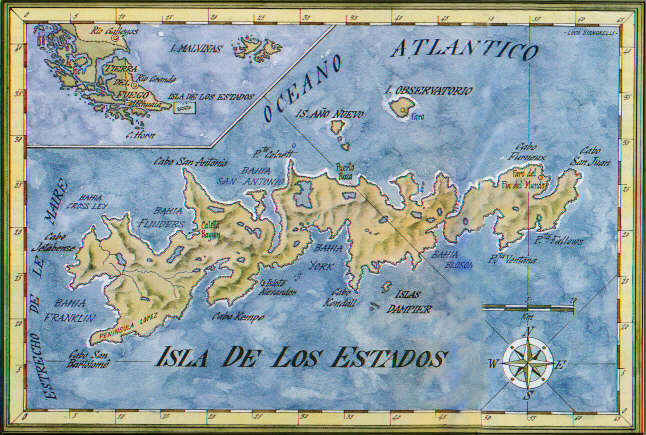
In this voyage, like hundreds and thousands of years ago, we are other Fueguians that venture out on a boat of no more than 6 meters in length, to cross the dangerous Le Maire Strait, the required route to” Chuanisin”, like our brothers Yamanas did before.

This has a strong symbolism because though being now extinct, they traveled these magnificent waters in a not very distant time in history, considering that the population was still of a few thousands in 1880.

Le Maire currents are now as strong and dangerous as they were for the Yamanas, and rocky coasts of the Isla de los Estados are just as rugged and frightening as they were for hundreds of adventurous explorers who described them in their writings with terror.

Such a treacherous and difficult territory was thought for the construction of a prison in late 1800 to confine the most dangerous prisoners, knowing that if they achieve escape had scarce resources in the barren land and deadly waters.
A recent history still in these places, and the love of a Fueguian for their land and the respect for the wild and untamed essence of his country, survives intact despite the inevitable passage of time..

No hay comentarios:

Publicar un comentario