STATEN LANT

Travel Diary of Jacob Le Maire and Schouten Wilhem, January 1616:

"Very early in the morning we saw land to the right at a mile distance, going southeast. We sounded and had 40 fathoms, with southwind along the coast of this mountainous land covered with snow. After noon, we saw land to the east which was a mountainous and broken land.These lands would be far about 8 miles one from the other.

Around noon the currents were large. We were in 54 degrees, 46 minutes. After noon, we found northwind that carried us to the strait. The wind dropped in the afternoon and this evening we were taken by the current and saw many penguins and whales.We were now close to the land recently discovered on the East. High and broken, apparently running southeastwards. We gave it the name "Statelant", in our language "Land of the States..."

With this vision of a rugged land elongated dutch sailors became the first men to discover the location of the island. Its initial name was due to the mistaken belief that it was a peninsula of Terra Australis. The Staten word referred to the 7 provinces of the Netherlands, which at that time were fighting for their independence. Years later, in 1643, Hendrick Brouwer circumnavigated Statenlant, noting that it was in fact an island and not a part of the continent. Thus, The Staten Island, a small bastion of rock of 65 miles long and a max. width of 16 kms., battered by waves and Antartic winds appeared in the future maritime cartography, separated from the island of Tierra del Fuego by the Strait of Le Maire.

George anson, a British commander, wrote in 1790: "It`s a horror territory, with peaks of prodigious height and terrifying precipices, it is difficult to imagine anything more savage and gloomy."

The dramatic description of Anson is due in large part to the rugged geography of the island. Its 530 square miles(including isla Año Nuevo(New Year Island) and Dampier and Menzies Islands, are comprised of twp mountain ranges that cross the island from end to end, with deep valleys, bogs, lakes, fjords, bays and cliffs that fall to the sea. Walking on the island is difficult.Everything around seems to be made of solid rock and the wild vegetation and the tall silhouettes of the mountains seem to close on the observer as walls.

These conditions and the isolation of its location, made this island a perfect fortness at sea among the mist. And indeed, over time, that was exactly what became


7 abr 2010

THE ORIGIN OF THE ISLAND

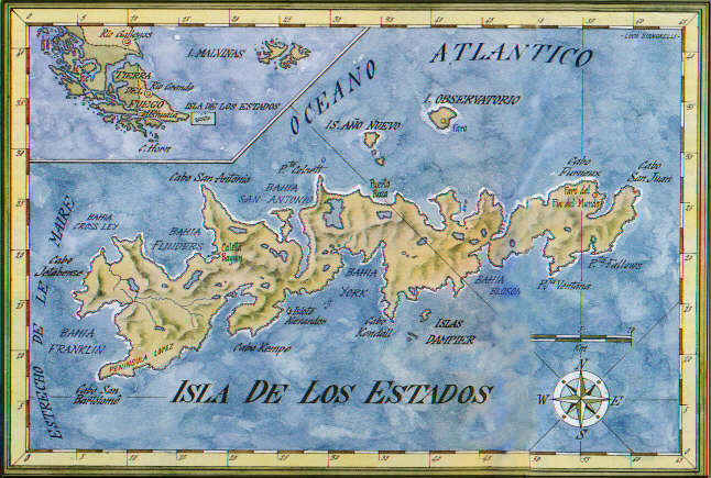
The project includes a kayak trip from Tierra del Fuego to Isla de los Estados and the subsequent circumnavigation of the island.

Isla de los Estados always held great attraction full of mystery, both for the European and for the indigenous people of the region.

“Chuanisin, Jaius o Koin Harri”... different names of the island over the years.

Isla de los Estados: Named by Willem Schouten and Jacob Le Maire in 1616.

Chuanisin: the “Land of Abundance” for Yamanas canoers.
Perhaps this was the reason why they sailed their bark canoes across the treacherous Strait of Le Maire, settling on its shores. Although according to archaeological remains, they never occupied the island for a long period of time.
What was the motivation for the Yamanas to arrive at the island using bark canoes?
Maybe they were hoping to find land with a abundant food, or most likely curiosity to see this unknown region in person.

Koin Harri: “The mountain of the Roots” for the Selk´nam people.

Jaius: the place of Origin for the Haush people. The Wizards considered it the source of their power and the cold region.
According to the sacred tradition of the Selk´nam and Haush people (native hunters on foot), two powerful shamans representing the Wind and Sea fought in the deep waters where the two great oceans collide. The Wind won the battle. For revenge, the Sea made two female powers to confront, the one who was defeated turned into a big rock and went to the bottom of the sea in the waters of the strait, for that reason they are so rough.

The Chaman who represented the Sea opened a gap and created the narrow “Sati” then put their daughters on the other side to protect them from a wizard.
The land separated from the Big Island was called “JAIUS”. The island stayed there alone, away from everyone.

Today, we are in search of THE LAND THAT WAS KEPT AWAY FROM ALL.

No hay comentarios:

Publicar un comentario